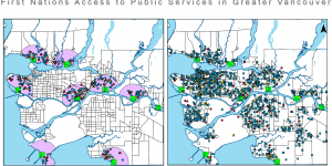
Our main idea going into this project, was to create an educational map that would look at the different services that are (or are not) available to First Nation communities today. We decided that it would be best, and most interesting to us, to look at those First Nation communities that are within the Greater Vancouver Area. Our final project became one to compare the immediate availability of public service amenities in a specifically determined buffer around the said communities.
Yevgen and I worked side by side throughout this project. We spent multiple hour in the computer lab in the Geography building as well as meetings outside of class in order to complete this study. I focused much of my efforts on the organizational side, keeping track of notes on our process as well as creating a flowchart to describe the work done to complete our map. Yev and I both worked together in lab to create the map and he also helped with many of the write ups.
We were able to gain some interesting perspectives as a result of our analysis. From our study, it can be seen that the presented First Nations communities are underserved by the public service amenities when comparing them to the entirety of Metro Vancouver. Such a conclusion was invoked due to the sparse distribution of the factors in question. It is seen that no point is in the direct center of the community, meaning that some travel by a vehicle is required, making the access not immediate. In addition, we have not observed any presence of community centers that intersect the boundary of access set up by us other than near the UBC Point Grey Campus; we are treating such result as an anomaly, due to such services being present on a university campus that firstly targets its students, and then the public. Furthermore, as the reserves move away from the city center, we observe a big decline in the availability of amenities, making it even harder to access simple life requirements. Such a pattern is especially profound in the areas like Tsawwassen, White Rock, and Deep Cove. Given this, we do not deem such availability to be profound, neither it is satisfactory to uphold the living standards of our First Nations Communities; hence making the conversation and action around the reconciliation movement even more prominent than ever. Our study helped uncover the not so pretty truth of living on the reserve, and we hope that this simple map is able to educate many and give some insight, on what it is like to live and dwell on a reserve that was set aside by the Crown. This work is not meant as a form of criticism, but rather as an educational tool. Additionally, we were able to learn a new tool in ArcMap, called "explode", this was found in editor mode. "Explode" allowed us to split up our buffer zones in order to create a buffer that did not include a need for traveling over water. I thoroughly enjoyed doing this project with Yev, and learned that it was much easier to set out specific time together to complete the project rather than working individually then attempting to come together at the end.
Our Final Project Analysis: Final Project Analysis
Our Final Map Production as a pdf: Final Map
I completed this project alongside, Yevgen Stets.